Mapping Services
 Is providing your utility survey plotted on to a print for your records or perhaps to fulfill a requirement from a homeowner, business owner, or a contractor.
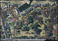
X-ray utilizes GPS capabilities that enable us collect the data from our survey and plot it to a map. This is an invaluable tool for many property owners as a way to eliminate the need for multiple mark-outs. Do it once and have Digital Mapping for future reference.
GET A QUOTE NOW
To learn more about this service, or obtain a quote, please complete the form below: